Buy all your VW California Accessories at the Club Shop Visit Shop
You are using an out of date browser. It may not display this or other websites correctly.
You should upgrade or use an alternative browser.
You should upgrade or use an alternative browser.
bvddobb
Top Poster
VIP Member
scabrero
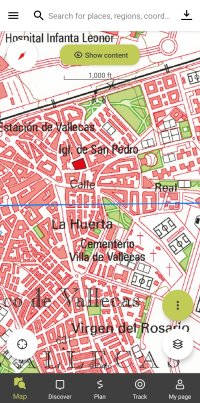
Mapas de España Básicos
Diseñada para ser muy sencilla de usar, sin tener que realizar ninguna configuración podrás conectarte a los servicios del IGN y al centro de descargas del CNIG para obtener mapas y rutas. Con esta aplicación podrás recorrer las rutas de los Parques Nacionales o las etapas del Camino de...
apps.apple.com
Organic Maps Offline Hike Bike
• Detailed offline maps with places that don't exist on other maps • Cycling routes, hiking trails, and walking paths • Contour lines, elevation profiles, peaks, and slopes • Turn-by-turn walking, cycling, and car navigation with voice guidance • Fast offline search • Bookmark everything you...
apps.apple.com
clarinetbcn
T5.1 Beach 140
Top Poster
VIP Member
I use the Wikiloc app for hiking, mountain biking and ski touring all over the world, including Picos de Europa. I have the deluxe version which I think costs about 5 or 6 euros a year. Great topographical maps that I've used from Scotland to Serbia, downloadable to use offline with GPS.
Last edited:
J
Jester
Top Poster
Lifetime VIP Member
Ok which app?Spain 2 - 1 Luxembourg
England 0
Thanks everyone
Barbara
VIP Member
- Messages
- 685
- Vehicle
- T5 Beach
Try Stanfords on line
https://www.stanfords.co.uk/picos-d...if-el-cornion-adrados-map-paper_9788493317799
Maps in Spain used to be known as military maps but I have not brought one for at least 20 years. I think the one I had for the pics was one like above that I got at a news agent in Spain. Stanfords in London which have online orders are good for delivery.
Sorry this is info on paper maps. I am dyslexic so read "app" as "map" however you may find a paper map useful if no signal on your phone.
Last edited:
Sad
Top Poster
Lifetime VIP Member
clarinetbcn
T5.1 Beach 140
Top Poster
VIP Member
Downloadable maps require no data or wifi signal in order to be viewable and fully functional with GPS. That’s what makes them useful when they’re downloaded to your phone. They do require the phone to have enough charge to turn on, so when hiking I usually put the phone in airplane mode to use GPS without the phone having to waste battery looking for a data or wifi signal. I carry a small external battery with 5 charges, and also paper maps as a backup.Try Stanfords on line
https://www.stanfords.co.uk/picos-d...if-el-cornion-adrados-map-paper_9788493317799
…you may find a paper map useful if no signal on your phone.
Last edited:
kp64zl
Top Poster
VIP Member
We’re big fans of the OS Maps apple here in England. Does anyone know of an equivalent app for Spain, specifically the Picos de Europe area please?
Iphigénie | The Hiking Map App
Iphigénie is the hiking map app for outdoor enthusiasts in France and around the world. Perfect for individuals (hikers, trailers, bikers, horse riders…) and professionals (guides, firefighters, surveyors, airmen, sailors, etc.) who need accurate maps. Find more than 40 detailed topographic basem…
apps.apple.com
I use iPhigenie. It is a mapping application that works across various countries. You need to subscribe to the app (£10ish per year) and then to the specific country. The Spanish maps are free, there is open cycle map which is also free, but there’s a charge for the french ign for example.
One great feature is that you can load two map layers and flip between them. So when we walked in the Pyrenees we flipped between French and Spanish maps .
There’s sat nav in it so you can work out where you are etc et . Can download for offline use etc.
Looks like the app is made by enthusiasts rather than big tech, so for some features you have to read the instructions
kp64zl
Top Poster
VIP Member
Also, for the Picos de Europa there are some reasonable paper maps for sale in the visitor centre. They are produced by the national park. But they rip easily
kp64zl
Top Poster
VIP Member
Oh sorry one more thing - gps /map apps are great for data harvesting (I.e privacy concerns). So worth checking each app’s behaviour in this respect.
Images show the behaviour of iphigenie (doesn’t collect data) and outdoor active (tracks you and sends data back to their servers). This info is available in the App Store if you scroll down
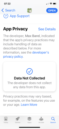
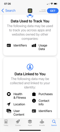
Images show the behaviour of iphigenie (doesn’t collect data) and outdoor active (tracks you and sends data back to their servers). This info is available in the App Store if you scroll down


The Tall Luthier
VIP Member
Oh god, the pressure! The pressure of a decision! The pressure of being a sole arbiter of nav apps! I'll have a look at recommend a winner.Ok which app?
kp64zl
Top Poster
VIP Member
I think the maps are the same across the apps — so you’re basically choosing the app that presents them.
ejmoore
2016 California Ocean 2.0 TDI
VIP Member
- Messages
- 692
- Vehicle
- T6 Ocean 204
An OutdoorActive premium account, which is something like £25/year subscription, gives you access to topo maps (ie Ordnance Survey equivalent) to anywhere in Europe, maybe worldwide.
P
Parkinjm
My experience of walking in Andalucia with TOPOgps has been mixed. The maps are good but the actual routes themselves haven’t always existed in the same form since people sometimes block them off. Paper maps like OS I have found difficult to obtain since maps were the prerogative of the military under Franco’s dictatorship and an organisation like OrdancecSurvey never came into being. The quality and availability is lacking.
Online maps as the thread shows are easier to obtain. Hiking and hiking tourism is also leading to the formation of lots of new hiking routes. Eg the Gran Senda de Málaga, the walking route round the whole province by stages.
Online maps as the thread shows are easier to obtain. Hiking and hiking tourism is also leading to the formation of lots of new hiking routes. Eg the Gran Senda de Málaga, the walking route round the whole province by stages.
Barbara
VIP Member
- Messages
- 685
- Vehicle
- T5 Beach
Are goggle maps any good? It is possible to download them although they do not seem to have cycle routes as good as those shown for the UK.
clarinetbcn
T5.1 Beach 140
Top Poster
VIP Member
Google maps for bicycle tend to be about the most efficient way to get from A to B, not necessarily the most interesting or beautiful. Have a look at https://www.wikiloc.com/wikiloc/map.do?sw=43.16803150945381,-4.84627503936486&ne=43.25846849054619,-4.72218496063514&place=Picos de Europa&page=1Are goggle maps any good? It is possible to download them although they do not seem to have cycle routes as good as those shown for the UK.
For paper topographical maps in Spain, https://www.editorialalpina.com/en/alpina-maps/maps/
ChrisandPenney52
VIP Member
An OutdoorActive premium account, which is something like £25/year subscription, gives you access to topo maps (ie Ordnance Survey equivalent) to anywhere in Europe, maybe worldwide.
This is what I use too, and the map quality is good everywhere I’ve tried it. And the route planning for walks is also excellent (taken from ViewRanger when they took them over).
Sent from my iPhone using Tapatalk
Suso100 GranC
As an Apple user and from Spain, I would recommend Maps and/or Waze for road use.We’re big fans of the OS Maps apple here in England. Does anyone know of an equivalent app for Spain, specifically the Picos de Europe area please?
For mountains and without coverage maps-me.
All free
Greetings and enjoy your stay.
If you need more information do not hesitate to contact me
The Tall Luthier
VIP Member
Thank you Suso, that is very kind of you to offer.As an Apple user and from Spain, I would recommend Maps and/or Waze for road use.
For mountains and without coverage maps-me.
All free
Greetings and enjoy your stay.
If you need more information do not hesitate to contact me
Similar threads
About us
The VW California Club is the worlds largest resource for all owners and enthusiasts of VW California campervans.

